Traveling is expensive. If you take the car, you have to count gasoline, but also the cost of tolls if you choose the highways. Google Maps will soon let you know how much a road trip will weigh on your wallet.
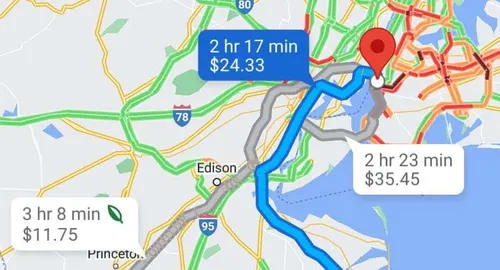
Google is releasing a new update for Maps on Android and iOS. By planning a trip, you can see how much you will have to pay if you pass through toll stations. Everything will be adjusted in real time in collaboration with local officials. You don't pay the same in the middle of the day than in the middle of the night.
Thus, with each planning, you will be able to have a precise idea of how much you will have to spend. Be careful though, this is an estimate, since Google does not (yet) take into account any reductions. As Android Police clarifies, you should also be aware that you have a total cost for your trip and cannot see the individual cost of each station.
Google Maps now informs you of the real cost of your trip

Of course, if you don't want to take the highway, it will always be possible to ask Google to use alternative routes. The journey will certainly be longer, but cheaper. Other options, such as fastest or greenest routes, will continue to appear. There will be something for everyone. If this new feature is interesting, it is not yet available form all users. Indeed, it only concerns the United States, Japan, India and Indonesia for the moment. Google promises us that other countries will soon get the feature, but without giving further details.
Google Maps therefore continues to improve in small steps. Recently, the air quality index was introduced. Apart from the routes, the software will also soon include much more detailed 3D views to make navigation even more pleasant and fun.
Popular News
Latest News
Loading


